摘要:
1. 引言 1.简介FindTask:搜索ArcGISServerRESTAPIBasedonastingvalue公开的伪服务。搜索可以在单层的一个区域上、在层的任何区域上或在多层的任何区域中进行。查询任务:已执行
- FindTask:Search a map service exposed by the ArcGIS Server REST API based on a string value. The search can be conducted on a single field
of a single layer, on many fields of a layer, or on many fields of
many layers.- QueryTask:Executes different types of query operations on a layer. The most common method used in this class is execute(), which executes the query as defined in the Query object that is passed as a parameter to the function. QueryTask.execute() returns a Promise that resolves to a FeatureSet, which contains the features in the layer that satisfy the Query.
- IdentifyTask: Performs an identify operation on the layers of a map service exposed by the ArcGIS Server REST API. Use IdentifyParameters to set the parameters for the identify operation and IdentifyResult to work with the results.
- 三种查询方式区别
| FindTask | IdentifyTask | QueryTask | |
|---|---|---|---|
| 查询方式 | 属性查询 | 属性查询/空间查询 | 属性查询/空间查询 |
| 查询图层 | 单个图层/多个图层 | 单个图层/多个图层 | 单个图层 |
| 统计 | 否 | 否 | 是 |
| 针对featureLayer |
- 说明
网上会有很多相关的文档,推荐大神王培晓的 ArcGIS API For Javascript之查询功能.此篇博客使用vue实现,api版本为4.10
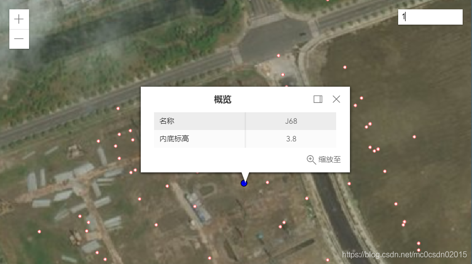
2.1 利用FindTask实现简单的属性查询
- 文档的dom节点加载完毕后,即vue中的mounted添加相关的模块
	"esri/tasks/FindTask",
	"esri/tasks/support/FindParameters"
- 添加属性查询控件,自定义input框,添加到view的右上角
	let element = document.createElement("input");
	element.className = "inputFindTask";
	this.currentView.ui.add(element, "top-right");
- 初始化查找
	let findTask = new FindTask({
		// 此处为自定义的地图服务,需要开启featureServices
		url: this.mapService.findTask
	});
	let findParameters = new FindParameters({
		// 查询字符串,默认会模糊查找
		searchText: "J68",
		// 查询的图层数组,对应序号可通过浏览器打开地图服务查看
		layerIds: [4],
		// 查询字段名称字符串数组
		searchFields: ["NAME"],
		// 如果做高亮显示需要返回geometry,即把要素返回
		returnGeometry: true
	});
- 添加input元素绑定事件
	element.onkeyup = function(e) {
		if (e.keyCode == 13) {
			findTask.execute(findParameters)
				.then(result => {
				    // 解析查询结果,将graphic数组渲染在view中
					getGraphics(result.results).forEach(graphic => {
						_this.currentView.graphics.add(graphic);

					})
				})
				.catch(error => console.log(error.message))
		}
	}
- 额外事件
     /**
      * 创建graphic
      */
     createGraphic:function(geometry,symbol,attribute,popupTemplate ){
         return new this.Grahic({
             geometry: geometry,
             symbol: symbol,
             attributes: attribute,
             popupTemplate: popupTemplate
         })
     }
	// 解析findResult 获取graphic的数组
	let getGraphics = function(results){
		let graphics = [];
		results.forEach(item => {
			let geometry = item.feature.geometry;
			let symbol = {
				type: "simple-marker", // autocasts as new SimpleMarkerSymbol()
				color: "blue",
				size: 8,
			};
			let attributes = item.feature.attributes;
			// popupTemplate 由两部分组成,title,content
			let popupTemplate = {
				title: "概览",
				// content中的内容可以手写,也可以利用内置表格展示字段值,这里采用第二种
				content: [{
					type: "fields",
					fieldInfos: [{
						fieldName: "名称",
						label: "名称",
					},
					{
						fieldName: "内底标高",
						label:'内底标高'
					}]
				}]
			};
			let graphic = _this.createGraphic(geometry,symbol,attributes,popupTemplate);
			graphics.push(graphic)
		})
		return graphics;
	};
2.2 利用QueryTask实现空间查询
2.2.1 说明
- 功能类似于ArcGIS中绘制矩形识别要素功能
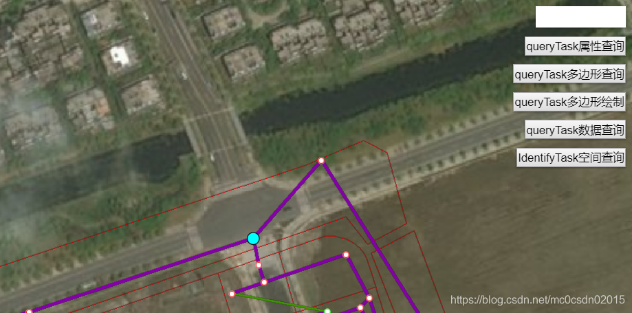
[外链图片转存失败(img-M80sF5P7-1564050286782)(./images/queryTask2.png)]
2.2.2 实现
- 引入模块,初始化查询
	let queryTask = new QueryTask({
		// 自定义的rest地图服务
		url: _this.mapService.QueryTask
	});
	let query = new Query({
		// 绘制的要素
		geometry:geometry,
		// 空间包含关系
		spatialRelationship:"contains",
		// 是否返回要素,可做后续的feature要素操作
		returnGeometry:true,
		// 返回要素内部的属性字段字符串数组,全选为["*"]
		outFields:["NAME"]
	});
- 引入模块,绘制要素
	"esri/views/draw/Draw";
	this.currentDraw = new Draw({view:this.currentView});
/**
 * 绘制多边形
 */
drawPolygon:function(){
	let _this=this;
	// 创建 graphic
	let createGraphic = function(vertices){
		// 创建多边形形状
		var polygon = new _this.Polygon({
			rings: [vertices],
			spatialReference: _this.currentView.spatialReference
		});
		// 创建绘制线条
		var lineSymbol = {
			type: "simple-line",
			color: "#23E3E7",
			width: 3
		};
		// 创建多边形的graphic
		var polygonGraphic = new _this.Graphic({
			geometry: polygon,
			symbol: lineSymbol
		});
		return polygonGraphic;
	}
	this.currentView.graphics.removeAll();
	// 使用绘制工具开始绘制polygon
	const action = this.currentDraw.create("polygon");
	this.currentView.focus();
	// fires when a vertex is added
	action.on("vertex-add", function (evt) {
		_this.currentView.graphics.add(createGraphic(evt.vertices));
	});

	// fires when the pointer moves
	action.on("cursor-update", function (evt) {
		_this.currentView.graphics.removeAll();
		_this.currentView.graphics.add(createGraphic(evt.vertices));
	});

	// fires when the drawing is completed
	action.on("draw-complete", function (evt) {
		_this.currentView.graphics.removeAll();
		_this.currentView.graphics.add(createGraphic(evt.vertices));

		_this.geometry = createGraphic(evt.vertices).geometry;
	});

	// fires when a vertex is removed
	action.on("vertex-remove", function (evt) {
		_this.currentView.graphics.removeAll();
		_this.currentView.graphics.add(createGraphic(evt.vertices));
	});
}
- 查询
	queryTask.execute(query)
	.then(result => {
		_this.currentView.graphics.removeAll();
		result.features.forEach(item => {
			_this.currentView.graphics.add(_this.createFeatures(item));
		})
	})
	.catch(error => console.log(error.message))
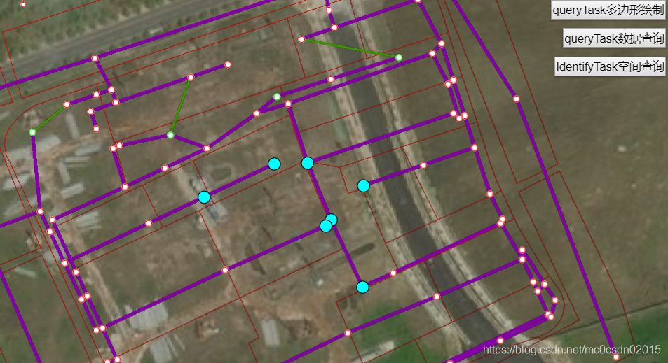
2.3 利用QueryTask进行属性查询
2.3.1 说明
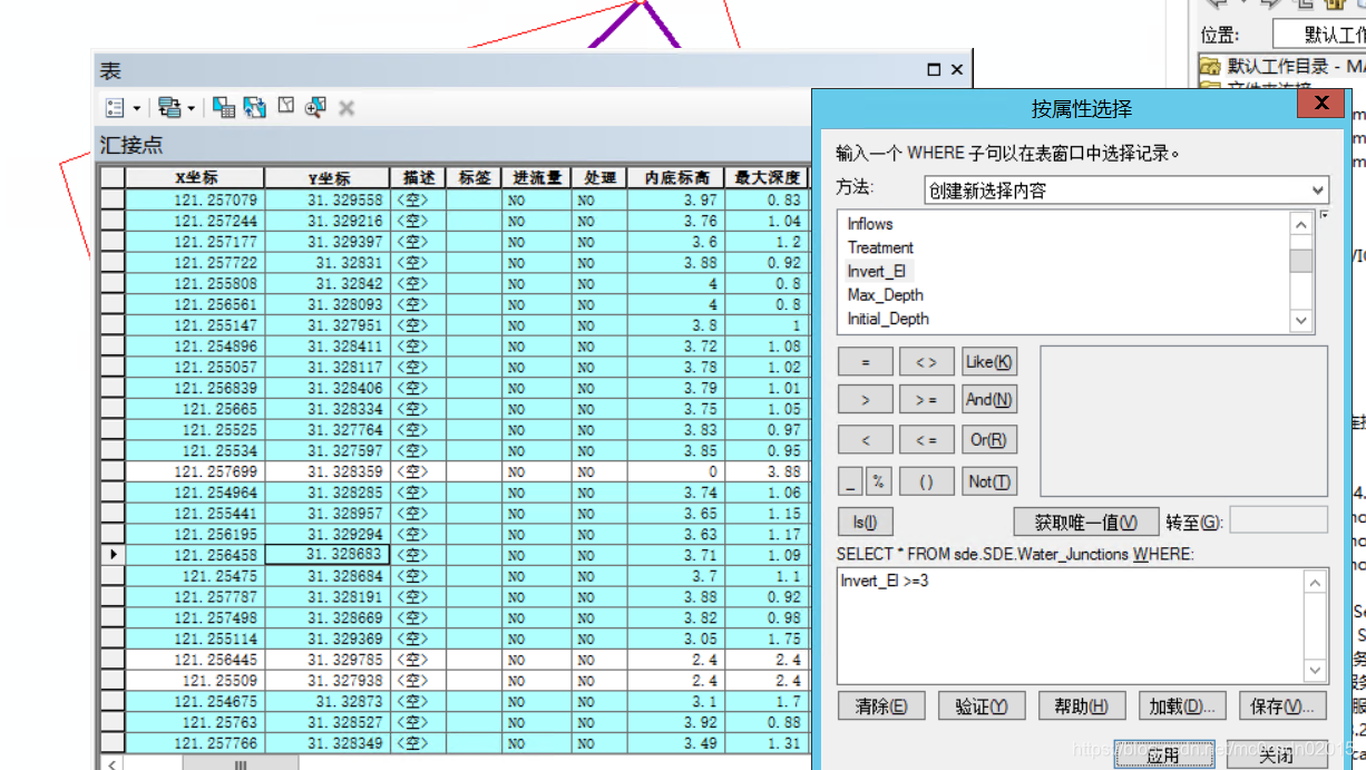
- 功能类似于ArcGIS中的按属性选择
2.3.2 实现
- 引入模块,初始化查询
	// 引入模块
	"esri/tasks/QueryTask",
	"esri/tasks/support/Query"
	// 初始化属性查询
	let queryTask = new QueryTask({
		// 这里选择自定义的rest地图服务
		url: _this.mapService.QueryTask
	});
	let query = new Query({
		// 查询条件,测试可使用arcgis属性表中的按属性选择
		where: "Invert_El >= 1",
		// 返回要素内部的属性字段字符串数组,全选为["*"]
		outFields: ["NAME"],
		// 是否返回要素,可做后续的feature要素操作
		returnGeometry: true
	});
- queryTask执行execute操作
	queryTask.execute(query)
	.then(result => {
		result.features.forEach(item => {
			//后续操作
		})
	})
	.catch(error => console.log(error.message))
2.4 利用IdentifyTask实现空间查询
2.4.1 说明
功能与QueryTask的区别在于可以查询多个图层
2.4.2 实现
- 引入模块,初始化查询
	"esri/tasks/IdentifyTask",
	"esri/tasks/support/IdentifyParameters",
	let identifyTask = new IdentifyTask({
		url:_this.mapService.IdentifyTask
	});
	let identifyParameters = new IdentifyParameters({
		// 查询要素
		geometry:_this.geometry,
		// 容差,单位为像素
		tolerance:3,
		// 查询图层id数组
		layerIds:[1,2,3,4,5,6,7,8,9,10,11],
		// 定义查询图层,所有图层("all"),可视图层("visible"),顶层图层("top")
		layerOption: "all",
		width:_this.currentView.width,
		height:_this.currentView.height,
		mapExtent:_this.currentView.extent,
		returnGeometry: true
	});
	identifyTask.execute(identifyParameters)
	.then(result => console.log(result))
	.catch(error => console.log(error.message))
- QueryTask模块有统计功能,此处没有展示
- 完整代码可访问 sean1224/blog-gis
- 对比arcgis api 的这三个查询模块有相似性:对应的任务和参数,使用excute函数运行得出结果;返回结果都是promise—