https://github.com/qgis/QGIS/blob/master/INSTALL.md
二、编译需求Following a summary of the required dependencies for building:
Required build tools: * CMake >= 3.10.0 * Flex >= 2.5.6 * Bison >= 2.4 * Python >= 3.7 Required build dependencies: * Qt >= 5.12.0 * Proj >= 4.9.3 * GEOS >= 3.4 * Sqlite3 >= 3.0.0 * SpatiaLite >= 4.2.0 * libspatialindex * GDAL/OGR >= 2.1 * Qwt >= 5.0 & (< 6.1 with internal QwtPolar) * expat >= 1.95 * QScintilla2 * QCA * qtkeychain (>= 0.5) * libzip Optional dependencies: * for GRASS providers and plugin - GRASS >= 7.0.0. * for georeferencer - GSL >= 1.8 * for PostGIS support - PostgreSQL >= 8.0.x * for gps plugin - gpsbabel * for mapserver export and PyQGIS - Python >= 3.6 * for python support - SIP >= 4.12, PyQt >= 5.3 must match Qt version, Qscintilla2 * for qgis mapserver - FastCGI * for oracle provider - Oracle OCI library |
Indirect dependencies:
Some proprietary formats (e.g., ECW and MrSid) supported by GDAL require proprietary third party libraries. QGIS doesn't need any of those itself to build, but will only support those formats if GDAL is built accordingly. Refer to http://gdal.org/formats_list.html ff. for instructions how to include those formats in GDAL.
三、Building on Windows using vs3.1 Other tools and dependencies
Download and install following packages:
Tool | Website |
CMake | |
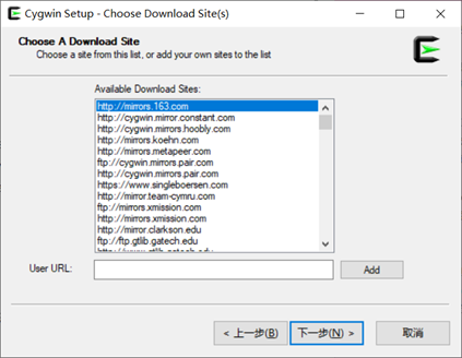
GNU flex, GNU bison and GIT | 在 windows 系统上提供的类 unix 环境,用于下载所需要的包。 http://cygwin.com/setup-x86.exe (32bit) or |
OSGeo4W | 用于 windows 系统里一系列的开源 gis 的发布。 http://download.osgeo.org/osgeo4w/osgeo4w-setup-x86_64.exe (推荐) |
ninja | https://github.com/ninja-build/ninja/releases/download/v1.7.2/ninja-win.zip |
For the QGIS build you need to install following packages from cygwin:
- bison
- flex
- git
and from OSGeo4W (select Advanced Installation):
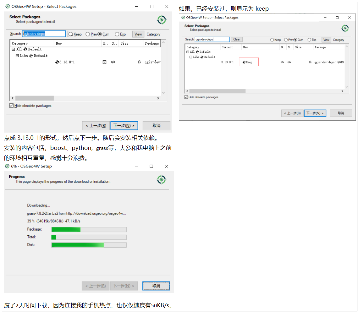
- qgis-dev-deps
This will also select packages the above packages depend on.
If you install other packages, this might cause issues. Particularly, make sure not to install the msinttypes package. It installs a stdint.h file in OSGeo4W[64]include, that conflicts with Visual Studio own stdint.h, which for example breaks the build of the virtual layer provider.
Earlier versions of this document also covered how to build all above dependencies. If you're interested in that, check the history of this page in the Wiki or the SVN repository.
ninja: copy ninja.exe to d:OSGeo4W64in
补充说明:
1. cygwin的安装
一步步安装,直至选择包的界面,分别搜索需以上的包,若未安装,会显示 skip,点击切换版本即可。下图为已安装,显示为 keep。
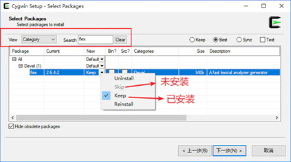
搜索了:flex, bison, ninja,。
2. OSGeo4W安装 (例如,若自己电脑上有QGIS 3.12安装版本,可省去这部分)
选择 Advanced Install,否则安装路径假设默认为 C:OSGeo4W64。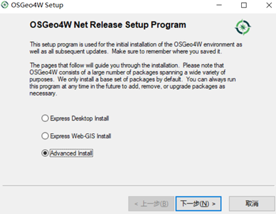
之后一步步安装,直至选择包界面。
后面的步骤省去,和cygwin类似。
到选择包界面时,输入 qgis-dev-deps,同样,若未安装,会显示为 skip,点击切换版本即可。
备注:
qgis-dev-deps要安装的内容如下。
avce00 (2.0.0-1) The AVCE00 commandline utilities for Arc/Info E00 conversion Required by: grass boost-libs (1.56.0-2) The Boost library (runtime libraries). Required by: libkml cairo (1.12.14-1) Cairo library Required by: grass curl (7.67.0-1) The CURL HTTP/FTP library and commandline utility. Required by: gdal-dev, proj-dev, netcdf, gdal, gdal111dll curl-ca-bundle (20191119-1) CURL CA certificates Required by: curl exiv2 (0.26-1) Image metadata library Required by: exiv2-devel exiv2-devel (0.26-1) Image metadata library (development) Required by: qgis-dev-deps expat (2.1.0-1) The Expat XML Parser library Required by: qgis-dev-deps, gdal-dev, ogdi, gpsbabel, gdal, exiv2, gdal111dll, libkml fcgi (2.4.1-2) FastCGI Library Required by: qgis-dev-deps fftw (3.3.3-1) Fast Fourier transformation library (Development) Required by: grass freexl (1.0.2-1) The FreeXL library for accessing Excel (.xls) spreadsheet. Required by: gdal-dev, spatialite, gdal, gdal111dll gdal (3.0.4-2) The GDAL/OGR library and commandline tools Required by: grass, gpsbabel, python3-gdal gdal-dev (3.1.0-273) The GDAL/OGR library and commandline tools (nightly master) Required by: qgis-dev-deps gdal111dll (1.11.3-1) The GDAL/OGR 1.11 DLL (backward compability package) Required by: liblas geos (3.8.1-1) The GEOS geometry library Required by: gdal-dev, spatialite, gdal, liblwgeom, gdal111dll gpsbabel (1.4.4-2) GPS file conversion plus transfer to/from GPS units Required by: grass grass (7.8.2-2) GRASS GIS Required by: qgis-dev-deps gs (9.07-1) Ghostscript Required by: grass gsl-devel (1.15-1) GNU Scientific Library (GSL; Development) Required by: qgis-dev-deps gsl-libs (1.15-1) GNU Scientific Library (GSL) Required by: gsl-devel hdf4 (4.2.14-1) The HDF4 library for reading and writing HDF4 format Required by: gdal-dev, gdal, gdal111dll hdf5 (1.10.4-1) The HDF5 library for reading and writing HDF5 format Required by: netcdf, gdal111dll iconv (1.14-1) Codepage translation Library Required by: qgis-dev-deps, grass, spatialite, freexl, cairo, gdal111dll iconv-vc14 (1.15-1) Codepage translation Library Required by: gdal-dev, gdal icu-libs (56.1-3) ICU (library) Required by: qtwebkit-qt5-libs laszip2 (2.2.0-3) The LASzip compression library (version 2) Required by: liblas libgeotiff (1.4.2-1) The Libgeotiff library, commandline tools and supporting tables. Required by: liblas, gdal111dll libjpeg (6b-4) A library for manipulating JPEG image format files Required by: gdal-dev, libtiff, gdal111dll libjpeg12 (6b-4) A library for manipulating 12bit JPEG image format files Required by: libtiff libkml (1.3.0-1) LibKML Required by: gdal liblas (1.8.0-1) The libLAS commandline utilities Required by: grass liblwgeom (3.0.0-2) liblwgeom Required by: spatialite libmysql (6.1.9-1) MySQL Client Library. Required by: gdal-dev, gdal, gdal111dll libpng (1.6.3-1) the official PNG reference library Required by: gdal-dev, grass, gdal libpng-vc14 (1.6.29-1) the official PNG reference library Required by: openjpeg libpq (11.5-1) The libpq library for accessing PostgreSQL + psql commandline client Required by: gdal-dev, gdal, gdal111dll libspatialindex (1.9.0-1) The libspatialindex library Required by: qgis-dev-deps libtiff (4.0.8-1) A library for manipulating TIFF format image files (runtime) Required by: grass, proj-dev, openjpeg, liblas, libgeotiff, gdal111dll libxml2 (2.9.1-1) An XML read/write library Required by: spatialite, cairo libzip-devel (1.2.0-2) libzip (development) Required by: qgis-dev-deps libzip-libs (1.2.0-2) libzip (runtime library) Required by: libzip-devel msvc2015 (1.0.0-1) msvc2015 Required by: spatialite, icu-libs | msvcrt (1.0.3-1) Microsoft Visual C/C++ Runtimes Required by: grass, oci-devel, shell, openjpeg, msvcrt2015, oci, opencl, setup, libkml msvcrt2008 (1.0.0-1) Microsoft Visual C/C++ 2008 Runtimes Required by: msvcrt msvcrt2010 (1.0.0-2) Microsoft Visual C/C++ 2010 Runtimes Required by: msvcrt, xerces-c-vc10 msvcrt2012 (1.0.0-2) Microsoft Visual C/C++ 2012 Runtimes. Required by: boost-libs msvcrt2013 (1.0.0-2) Microsoft Visual C/C++ 2013 Runtimes Required by: grass, liblas msvcrt2015 (1.0-2) Microsoft Visual C/C++ 2015 Runtimes Required by: grass, libspatialindex, proj-dev, curl, geos, libmysql, sqlite3, libpq, xerces-c, hdf4, ogdi, iconv-vc14, zstd, libtiff, gdal, proj, libzip-libs, python3-core, qt5-libs, liblwgeom, msvc2015, exiv2, protobuf, openssl, hdf5, szip, laszip2, xz netcdf (4.7.3-1) The NetCDF library and commands for reading and writing NetCDF format Required by: gdal-dev, gdal, gdal111dll oci (12.1.0.1.0-1) Oracle Instant Client Required by: oci-devel oci-devel (12.1.0.1.0-1) Oracle Instant Client (Development) Required by: qgis-dev-deps ogdi (4.1.0-1) OGDI data access library (mainly for VPF reading) Required by: gdal-dev, gdal, gdal111dll opencl (2.0.10-5) KhronosGroup OpenCL runtime Required by: opencl-devel opencl-devel (2.0.10-4) KhronosGroup OpenCL development files Required by: qgis-dev-deps openjpeg (2.3.0-1) OpenJPEG Required by: gdal-dev, gdal, gdal111dll openssl (1.1.1d-2) OpenSSL Cryptography (Runtime) Required by: curl, libpq, python3-core, qt5-libs openssl10 (1.0.2j-1) OpenSSL 1.0 Cryptography (Old Runtime) Required by: libzip-libs, openssl pdcurses (3.4-2) PDCurses (MinGW built) Required by: grass proj (6.3.1-1) The PROJ library and commands for coordinate system transformations. Required by: grass, spatialite, liblas, gdal, liblwgeom, gdal111dll proj-datumgrid (1.8-1) Assorted PROJ datum grid shift files Required by: proj-dev, liblas, proj proj-dev (7.1.0-37) The PROJ library and commands for coordinate system transformations (nightly master). Required by: gdal-dev proj-dev-data (1.1-4) The PROJ data (nightly master). Required by: proj-dev proj-hpgn (1.0-1) PROJ.4 HPGN (HARN) grid shift files Required by: proj-dev, liblas, proj protobuf (3.11.4-2) Protocol Buffers - Google's data interchange format Required by: protobuf-devel protobuf-devel (3.11.4-2) Protocol Buffers - Google's data interchange format (development) Required by: qgis-dev-deps pyqt5 (5.11.3-2) Python bindings for Qt5. Required by: qgis-dev-deps, python3-qscintilla python3-core (3.7.0-4) Python3 core interpreter and runtime Required by: pyqt5, python3-devel, python3-qscintilla, python3-nose2, python3-future, python3-pyyaml, python3-mock, python3-six, sip-qt5, python3-gdal, python3-matplotlib, python3-wx, python3-numpy, python3-pillow, python3-pip, python3-ply, python3-pyopengl, python3-pywin32, python3-coverage, python3-pbr, python3-pyparsing, python3-cycler, python3-kiwisolver, python3-python-dateutil, python3-psycopg2-binary, python3-setuptools python3-coverage (4.5.1-1) Code coverage measurement for Python Required by: python3-nose2 python3-cycler (0.10.0-2) Composable style cycles Required by: python3-matplotlib python3-devel (3.7.0-1) Python3 library and header files Required by: qgis-dev-deps python3-future (0.16.0-2) Clean single-source support for Python 3 and 2 Required by: qgis-dev-deps python3-gdal (3.0.4-2) The GDAL/OGR Python3 Bindings and Scripts Required by: grass python3-kiwisolver (1.1.0-1) A fast implementation of the Cassowary constraint solver Required by: python3-matplotlib python3-matplotlib (3.1.3-1) Python plotting package Required by: grass python3-mock (2.0.0-2) Rolling backport of unittest.mock for all Pythons Required by: qgis-dev-deps python3-nose2 (0.8.0-1) nose2 is the next generation of nicer testing for Python Required by: qgis-dev-deps python3-numpy (1.18.1-1) NumPy is the fundamental package for array computing with Python. Required by: grass, python3-gdal, python3-matplotlib python3-pbr (4.3.0-1) Python Build Reasonableness Required by: python3-mock python3-pillow (5.3.0-1) Python Imaging Library (Fork) Required by: grass python3-pip (20.0.2-1) The PyPA recommended tool for installing Python packages. Required by: grass python3-ply (3.11-2) Python Lex & Yacc Required by: grass python3-psycopg2 (2.8.4-1) psycopg2 - Python-PostgreSQL Database Adapter (transitional) Required by: grass | python3-psycopg2-binary (2.8.4-1) psycopg2 - Python-PostgreSQL Database Adapter Required by: python3-psycopg2 python3-pyopengl (3.1.0-1) Standard OpenGL bindings for Python Required by: grass python3-pyparsing (2.4.6-1) Python parsing module Required by: python3-matplotlib python3-python-dateutil (2.8.1-1) Extensions to the standard Python datetime module Required by: python3-matplotlib python3-pywin32 (224-1) Python for Window Extensions Required by: grass python3-pyyaml (5.3-1) YAML parser and emitter for Python Required by: qgis-dev-deps python3-qscintilla (2.10.8-1) Python3 bindings for Qt5 QScintilla Required by: qgis-dev-deps python3-setuptools (45.2.0-1) Easily download, build, install, upgrade, and uninstall Python packages Required by: python3-kiwisolver python3-six (1.14.0-1) Python 2 and 3 compatibility utilities Required by: qgis-dev-deps, grass, python3-nose2, python3-mock, python3-wx, python3-cycler, python3-python-dateutil python3-wx (4.0.7-1) wxPython - Python3 bindings for wxWidgets Required by: grass qca-qt5-devel (2.1.3-1) Qt5 Cryptographic Architecture headers and libraries (Development) Required by: qgis-dev-deps qca-qt5-libs (2.1.3-1) Qt5 Cryptographic Architecture runtime libraries Required by: qgis-dev-deps qscintilla-qt5 (2.10.8-1) Qt5 source code editing component. Required by: qgis-dev-deps, python3-qscintilla qt5-devel (5.11.2-1) Qt5 headers and libraries (Development) Required by: qgis-dev-deps, qca-qt5-devel, qtkeychain-qt5-devel qt5-libs (5.11.2-1) Qt5 runtime libraries Required by: pyqt5, qca-qt5-devel, qca-qt5-libs, qscintilla-qt5, qt5-devel, qtkeychain-qt5-devel, qtwebkit-qt5-libs, qtwebengine-qt5-libs, qwt-libs-qt5, qtkeychain-qt5-libs qt5-libs-debug (5.11.2-1) Qt5 runtime libraries (debug version) Required by: qgis-dev-deps qtkeychain-qt5-devel (0.9-1) Platform-independent Qt API for storing passwords securely. (Development) Required by: qgis-dev-deps qtkeychain-qt5-libs (0.9-1) Platform-independent Qt API for storing passwords securely. Required by: qtkeychain-qt5-devel qtwebengine-qt5-libs (5.10.1-1) WebEngine for Qt5 Required by: pyqt5 qtwebkit-qt5-devel (5.212-1) WebKit for Qt5 (development) Required by: qgis-dev-deps qtwebkit-qt5-libs (5.212-1) WebKit for Qt5 Required by: pyqt5, qtwebkit-qt5-devel, qtwebkit-qt5-libs-debug qtwebkit-qt5-libs-debug (5.9.1-1) WekKit for Qt5 (debug libraries) Required by: qgis-dev-deps qwt-devel-qt5 (6.1.3-5) Qt5 widgets library for technical applications (Development) Required by: qgis-dev-deps qwt-libs-qt5 (6.1.3-5) Qt5 widgets library for technical applications (runtime) Required by: qwt-devel-qt5 rbatch (149-4) Windows batchfiles for use with R Required by: grass setup (1.0.7-16) OSGeo4W Installer/Updater Required by: shell shell (1.0.2-4) OSGeo4W Command Shell Required by: expat, fcgi, gdal-dev, gsl-devel, iconv, python3-qscintilla, qca-qt5-devel, qscintilla-qt5, qt5-libs-debug, qwt-devel-qt5, qtkeychain-qt5-devel, libpng, libjpeg, liblas, avce00, gpsbabel, pdcurses, zlib, fftw, cairo, gsl-libs, qwt-libs-qt5, libxml2, setup, libpng-vc14, libgeotiff, gdal111dll, laszip2, libjpeg12 sip-qt5 (4.19.14-1) Python3/C++ bindings generator (Development) Required by: qgis-dev-deps, pyqt5 spatialite (4.3.0a-6) The SpatiaLite library for adding spatial capabilities to SQLite3 DBMS. Required by: qgis-dev-deps, gdal-dev, gdal, gdal111dll sqlite3 (3.29.0-1) The SQLite3 library for accessing SQLite3 database files. Required by: gdal-dev, spatialite, proj-dev, gdal, python3-core, qt5-libs, gdal111dll szip (2.1.1-1) SZIP compression library Required by: hdf4, hdf5 xerces-c (3.2.0-1) The Xerces-C 3 library for parsing XML files (runtime) Required by: gdal-dev, gdal xerces-c-vc10 (3.1.1-1) The Xerces-C 3 library for parsing XML files Required by: gdal111dll xz (5.2.3-1) XZ-format compression library Required by: libtiff, gdal zlib (1.2.8-1) The zlib compression and decompression library (runtime) Required by: grass, qt5-libs-debug, ogdi, openjpeg, gpsbabel, libtiff, cairo, qt5-libs, exiv2, protobuf, libkml zstd (1.3.2-1) Zstandard Long Range Match Finder (runtime) Required by: gdal-dev, grass, gdal, zstd-bin zstd-bin (1.3.2-1) Zstandard Long Range Match Finder (binary) Required by: grass |
上面这一步是输入qgis-dev-deps ,其他的都不要,如果以前安装过QGIS最好要换一个安装目录,因为msinttypes中的头文件可能与VS2015中的文件件冲突,官方原话是这样的
接下来把git上下载的QGIS源码(建议用移动网络手机WiFi热点下载,实测电信30kiB/s, 移动 4G通用流量 500kiB/s,5G套餐流量,使用4G手机,最快达到5.05 MiB/s)。
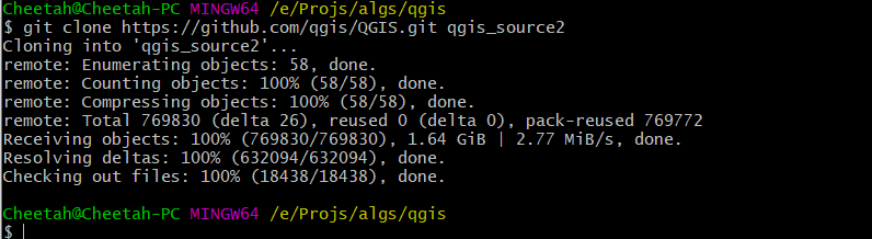
可以看出,在2020.4.27的时候,qgis的源码已经达到了 1.64GB,下载时,一定要找一个网络比较稳定的时候。否则直接git clone将非常耗时。我之所以使用git clone, 是为了日后直接关联到 github远程仓库,同步远程仓库的
将源码文件夹解压出来,我是把文件都放在“OSGeo4W”安装的父目录下,当然这个是可以自定义的。例如,放到一个编译qgis源码的父目录下 E:Projsalgsqgis。
把ninj解压出来的EXE文件放入XXXOSGeo4W64in目录中。
3.2 Setting up the Visual Studio project with Cmake
环境设置
以下保存为批处理文件 XXXqgis-dev.bat,其中具体的路径,替换成自己机子环境对应的路径,
其中的路径包括 vs 、window sdk、OSGeo、cygwin64等。
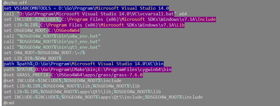
@echo off |
备注:
1)如果是vs2017, 上面两行蓝色的内容,并不好填写,可以省去。在cmake的时候,可以自动弹出窗口,选择设置。
2)以上表格中的内容的路径,以D:/Pros/Office/QGIS_Dev/OSGeo4W/apps/Python37/形式填写,否则cmake得到的vs工程里,安装将会遇到"/p"的问题。
New my file
@echo off |
在D:QGIS目录下按住shift键不放,右击鼠标选择 “在此处打开power shell 窗口(s)” ,输入下面命令进入cmake窗口。
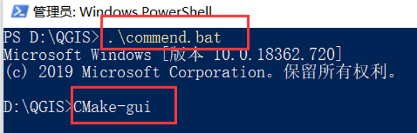
cmake
双击以上保存的 qgis-dev.bat,输入 cmake-gui,会弹出 cmake 的配置界面,写好 qgis 源码目录及build 目录。
build目录,要放到下载的qgis的源码根目录下
点击Configure后可能会出现一些错误,找到相应的路径添加上去就行了,下面是我的路径。
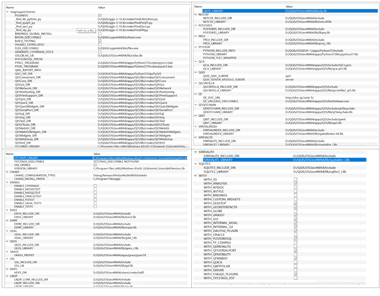
对上述cmake界面中的内容进行修改:
Enable test
Install please
Configure后,出现如下内容。
Selecting Windows SDK version 10.0.17763.0 to target Windows 10.0.18363. QGIS version: 3.13.0 Master (31300) Found OpenCL C++ headers: D:/Pros/Office/QGIS_Dev/OSGeo4W/include Could not find GRASS 7 Found Proj: D:/Pros/Office/QGIS_Dev/OSGeo4W/lib/proj_i.lib version 6 (6.3.1) Found GEOS: D:/Pros/Office/QGIS_Dev/OSGeo4W/lib/geos_c.lib (3.8.1) Found GDAL: D:/Pros/Office/QGIS_Dev/OSGeo4W/lib/gdal_i.lib (3.0.4) Found Expat: D:/Pros/Office/QGIS_Dev/OSGeo4W/lib/expat.lib Found Spatialindex: D:/Pros/Office/QGIS_Dev/OSGeo4W/lib/spatialindex-64.lib Found Qwt: D:/Pros/Office/QGIS_Dev/OSGeo4W/apps/Qt5/lib/qwt.lib (6.1.3) Found libzip: D:/Pros/Office/QGIS_Dev/OSGeo4W/lib/zip.lib Found Sqlite3: D:/Pros/Office/QGIS_Dev/OSGeo4W/lib/sqlite3_i.lib Found Protobuf: D:/Pros/Office/QGIS_Dev/OSGeo4W/lib/libprotobuf.lib Found zlib: D:/Pros/Office/QGIS_Dev/OSGeo4W/lib/zlib.lib Found PostgreSQL: D:/Pros/Office/QGIS_Dev/OSGeo4W/lib/libpq.lib Found SpatiaLite: D:/Pros/Office/QGIS_Dev/OSGeo4W/lib/spatialite_i.lib Qt WebKit support enabled Found Qt version: 5.11.2 Found QScintilla2: D:/Pros/Office/QGIS_Dev/OSGeo4W/apps/Qt5/lib/qscintilla2_qt5.lib (2.10.8) Found QtKeychain: D:/Pros/Office/QGIS_Dev/OSGeo4W/apps/Qt5/lib/qt5keychain.lib Found QCA: D:/Pros/Office/QGIS_Dev/OSGeo4W/apps/Qt5/lib/qca-qt5.lib (2.1.3) Pedantic compiler settings enabled Found Python executable: D:/Pros/Office/QGIS_Dev/OSGeo4W/bin/python3.exe Found Python version: 3.7.0 Found Python library: D:/Pros/Office/QGIS_Dev/OSGeo4W/apps/Python37/libs/python37.lib Found Python site-packages: D:/Pros/Office/QGIS_Dev/OSGeo4W/apps/Python37/Lib/site-packages Found PyQt5 version: 5.11.3 Found SIP version: 4.19.14 Found QScintilla2 PyQt module: 2.10.8 txt2tags not found - disabled Found exiv2: D:/Pros/Office/QGIS_Dev/OSGeo4W/lib/exiv2.lib Could NOT find PkgConfig (missing: PKG_CONFIG_EXECUTABLE) Found GSL: D:/Pros/Office/QGIS_Dev/OSGeo4W/lib/gsl.lib;D:/Pros/Office/QGIS_Dev/OSGeo4W/lib/cblas.lib Using PROJ 6 srs database. Ctest Binary Directory set to: E:/Projs/algs/qgis/qgis_source/build/output/bin Configuring done |
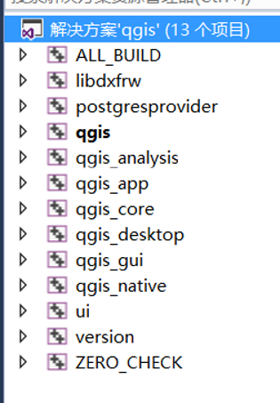
点击Open Project后会打开VS2015,打开后出现的工程项目比较多,如果只要基本功能的话,可以只保留下面几项,如果后期需要再加上。
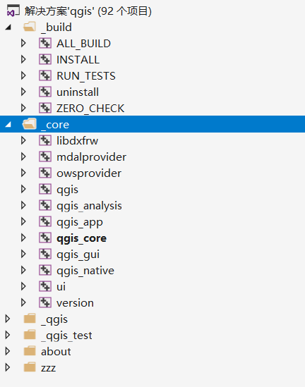
右键qgis工程,选择”设为启动项目“,然后右键ALL_BULID“生成”。
在编译过程中会出现一些错误与警告,可以参考这个百度文库尾部。
打开后,项目非常多,无论是编译、还是浏览,都非常慢。我们只需核心的几个库,其它的都移除。先把主程序运行起来,其它的插件若有需要再添加。
- qgis:QGIS可执行程序
- qgis_native:依赖项
- libdxfrw:依赖项
- qgis_app:
- qgis_analysis:依赖项
- qgis_core:依赖项,QGIS核心库
- qgis_gui:依赖项,QGIS核心库
- ui:QGIS所有的界面
- gdalprovider:读取栅格数据驱动
- ogrprovider:读取矢量数据驱动
- version:版本
由于源代码为 utf-8 编码,本机 locale 为中文,编译时可能出现 ”Newline in constant“ 的错误,需显示告诉编译器源码为 utf-8 :
右键-Properties-- c/c++,Command Line,Addtional Options 里添加:
/source-charset:utf-8
编译选项选择“RelWithDebInfo”,进行编译。由于源码比较多,先编译 core、native。总体耗时比较久,可能30分钟以上。
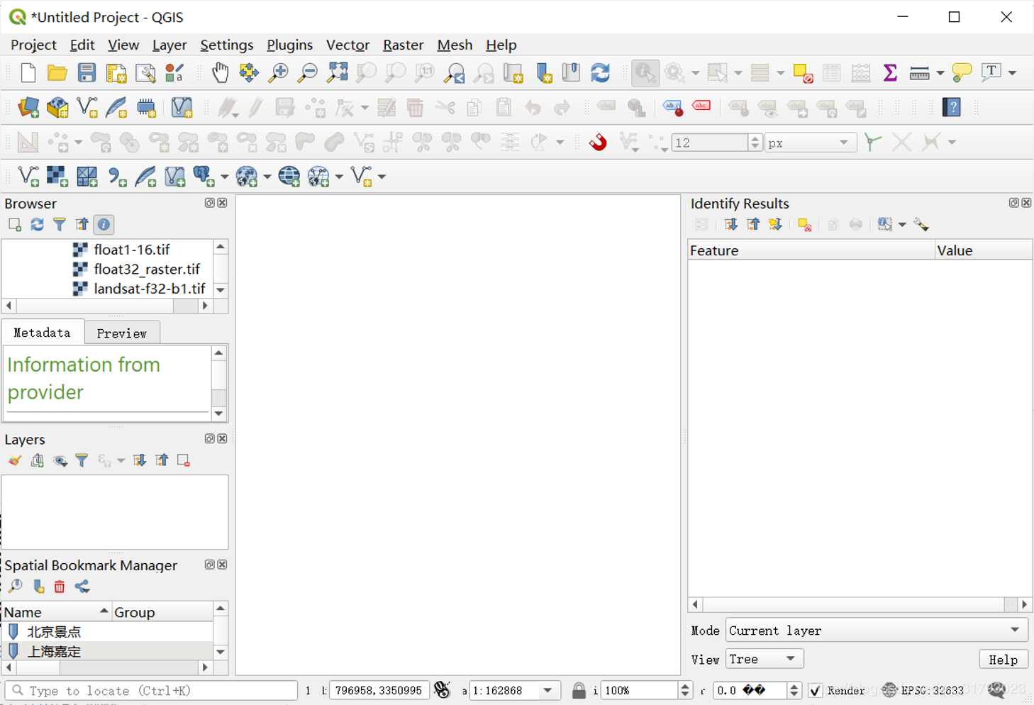
生成“后运行就会出现下面结果。
备注:
为了在vs工程中,将工程分门别类的合并到文件夹内,可以如下设置:
cmakeCMakeHelper.cmake | cmakeCMakeHelper_end.cmake |
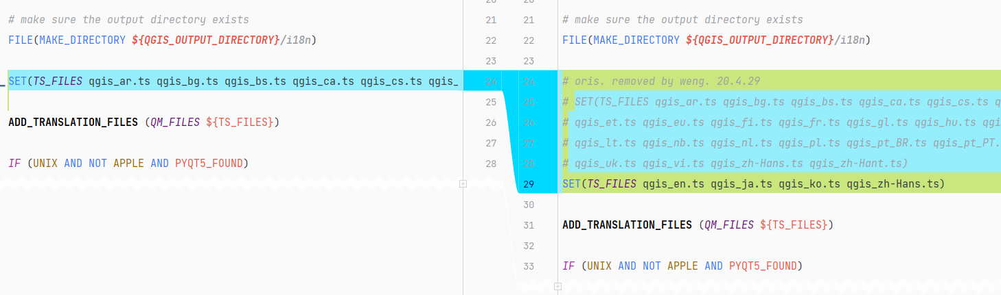
# for folders in vs studio .sln projects. # added by weng. 20.4.27 # Enable solution folders. set_property(GLOBAL PROPERTY USE_FOLDERS ON) set(CMAKE_TARGETS_ROOT_FOLDER "_build") set_property(GLOBAL PROPERTY PREDEFINED_TARGETS_FOLDER ${CMAKE_TARGETS_ROOT_FOLDER}) set(QGIS_CORE_ROOT_FOLDER "_core") set(QGIS_QGIS_LIBS_ROOT_FOLDER "_qgis") set(QGIS_QGIS_TEST_ROOT_FOLDER "_qgis_test") set(QGIS_ABOUT_ROOT_FOLDER "about") set(QGIS_ZZZ_ROOT_FOLDER "zzz") set(QGIS_SERVER_ROOT_FOLDER "server") # Wrapper for test executables. # macro(QGIS_ADD_TEST TARGET_NAME) # if(TESTS_ENABLED) # # ${ARGN} will store the list of source files passed to this function. # add_executable(${TARGET_NAME} ${ARGN}) # set_target_properties(${TARGET_NAME} PROPERTIES FOLDER ${QGIS_QGIS_TEST_ROOT_FOLDER}/${FOLDER_NAME}) # target_link_libraries(${TARGET_NAME} colmap ${Boost_UNIT_TEST_FRAMEWORK_LIBRARY}) # add_test("${FOLDER_NAME}/${TARGET_NAME}" ${TARGET_NAME}) # if(IS_MSVC) # install(TARGETS ${TARGET_NAME} DESTINATION bin/) # endif() # endif() #endmacro(QGIS_ADD_TEST) | # # weng for qgis test folders. 20.4.27 # set_target_properties(clean-staged-${plugin} PROPERTIES FOLDER ${QGIS_ZZZ_ROOT_FOLDER}/) set_target_properties(libdxfrw PROPERTIES FOLDER ${QGIS_CORE_ROOT_FOLDER}/) set_target_properties(mdalprovider PROPERTIES FOLDER ${QGIS_CORE_ROOT_FOLDER}/) set_target_properties(owsprovider PROPERTIES FOLDER ${QGIS_CORE_ROOT_FOLDER}/) set_target_properties(postgresprovider PROPERTIES FOLDER ${QGIS_CORE_ROOT_FOLDER}/) set_target_properties(qgis PROPERTIES FOLDER ${QGIS_CORE_ROOT_FOLDER}/) set_target_properties(qgis_3d PROPERTIES FOLDER ${QGIS_CORE_ROOT_FOLDER}/) set_target_properties(qgis_analysis PROPERTIES FOLDER ${QGIS_CORE_ROOT_FOLDER}/) set_target_properties(qgis_app PROPERTIES FOLDER ${QGIS_CORE_ROOT_FOLDER}/) set_target_properties(qgis_core PROPERTIES FOLDER ${QGIS_CORE_ROOT_FOLDER}/) set_target_properties(qgis_desktop PROPERTIES FOLDER ${QGIS_CORE_ROOT_FOLDER}/) set_target_properties(qgis_gui PROPERTIES FOLDER ${QGIS_CORE_ROOT_FOLDER}/) set_target_properties(qgis_native PROPERTIES FOLDER ${QGIS_CORE_ROOT_FOLDER}/) set_target_properties(ui PROPERTIES FOLDER ${QGIS_CORE_ROOT_FOLDER}/) set_target_properties(version PROPERTIES FOLDER ${QGIS_CORE_ROOT_FOLDER}/) # uninstall set_target_properties(uninstall PROPERTIES FOLDER ${CMAKE_TARGETS_ROOT_FOLDER}/) # weng for qgis test folders. 20.4.27 # server # not all server about projects. # weng for qgis test folders. 20.4.29 set_target_properties(qgis_server_full PROPERTIES FOLDER ${QGIS_SERVER_ROOT_FOLDER}/) set_target_properties(wms PROPERTIES FOLDER ${QGIS_SERVER_ROOT_FOLDER}/) set_target_properties(wfs PROPERTIES FOLDER ${QGIS_SERVER_ROOT_FOLDER}/) set_target_properties(wcs PROPERTIES FOLDER ${QGIS_SERVER_ROOT_FOLDER}/) set_target_properties(wfs3 PROPERTIES FOLDER ${QGIS_SERVER_ROOT_FOLDER}/) set_target_properties(wmts PROPERTIES FOLDER ${QGIS_SERVER_ROOT_FOLDER}/) set_target_properties(qgis_server PROPERTIES FOLDER ${QGIS_SERVER_ROOT_FOLDER}/) set_target_properties(qgis_mapserv.fcgi PROPERTIES FOLDER ${QGIS_SERVER_ROOT_FOLDER}/) set_target_properties(qgis_serverquerystringparametertest PROPERTIES FOLDER ${QGIS_SERVER_ROOT_FOLDER}/) |
然后设置1:
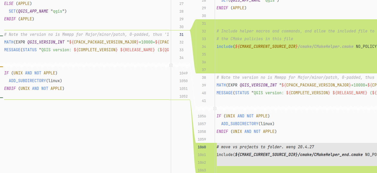
# Include helper macros and commands, and allow the included file to override
# the CMake policies in this file
include(${CMAKE_CURRENT_SOURCE_DIR}/cmake/CMakeHelper.cmake NO_POLICY_SCOPE)
# move vs projects to folder. weng 20.4.27
include(${CMAKE_CURRENT_SOURCE_DIR}/cmake/CMakeHelper_end.cmake NO_POLICY_SCOPE)
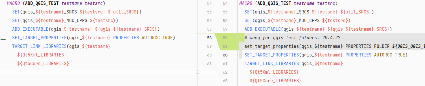
放置类别2:
# weng for qgis test folders. 20.4.27
set_target_properties(qgis_${testname} PROPERTIES FOLDER ${QGIS_QGIS_TEST_ROOT_FOLDER}/)
语言设置:
运行
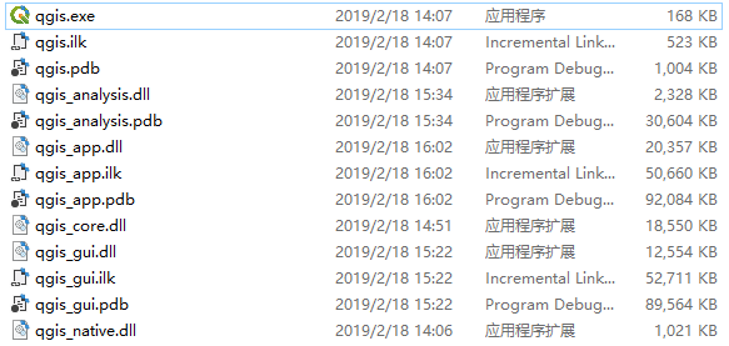
build 完成后,输出在 C:OSGeo4W64QGISuildoutputinRelWithDebInfo
gis 依赖比较多,可通过设置环境变量的方式来运行。以下内容保存为 qgis.bat。
@echo off
set OSGEO4W_ROOT=C:OSGeo4W64
call "%OSGEO4W_ROOT%ino4w_env.bat"
call "%OSGEO4W_ROOT%inpy3_env.bat"
call "%OSGEO4W_ROOT%inqt5_env.bat"
start qgis
双击运行 qgis.bat。
问题及解决
(0)CMake问题: ADD_SUBDIRECTORY given source "native" which is not an existing directory.
问题,提示:
CMake Error at src/CMakeLists.txt:1 (ADD_SUBDIRECTORY): ADD_SUBDIRECTORY given source "native" which is not an existing directory. Found exiv2: D:/Pros/Office/QGIS_Dev/OSGeo4W/lib/exiv2.lib CMake Error at src/CMakeLists.txt:9 (ADD_SUBDIRECTORY): ADD_SUBDIRECTORY given source "ui" which is not an existing directory. CMake Error at src/CMakeLists.txt:14 (ADD_SUBDIRECTORY): ADD_SUBDIRECTORY given source "providers" which is not an existing directory. CMake Error at src/CMakeLists.txt:22 (ADD_SUBDIRECTORY): ADD_SUBDIRECTORY given source "test" which is not an existing directory. CMake Error at src/CMakeLists.txt:26 (ADD_SUBDIRECTORY): ADD_SUBDIRECTORY given source "plugins" which is not an existing directory. CMake Error at src/CMakeLists.txt:34 (ADD_SUBDIRECTORY): ADD_SUBDIRECTORY given source "python" which is not an existing directory. CMake Error at src/CMakeLists.txt:50 (ADD_SUBDIRECTORY): ADD_SUBDIRECTORY given source "process" which is not an existing directory. Using PROJ 6 srs database. CMake Error at CMakeLists.txt:993 (ADD_SUBDIRECTORY): ADD_SUBDIRECTORY given source "tests" which is not an existing directory. |
原因,解压qgis库时,发现没有解压完整。
(1) protobuf(C++)的使用(windows)
https://blog.csdn.net/pengshengli/article/details/90378455
https://github.com/protocolbuffers/protobuf/releases
(2) Qt5Gui_DIR
https://blog.csdn.net/webzhuce/article/details/79960512
WITH_QTWEBKIT 取消
WITH_Qt5SerialPort 取消
修改cmakelist, 新添加如下内容。
set(Qt5Gui_DIR "C:/Program/Dev/Qt/Qt5.13.1/5.13.1/msvc2017_64/lib/cmake/Qt5Gui/") set(Qt5Widgets_DIR "C:/Program/Dev/Qt/Qt5.13.1/5.13.1/msvc2017_64/lib/cmake/Qt5Widgets/") set(Qt5Network_DIR "C:/Program/Dev/Qt/Qt5.13.1/5.13.1/msvc2017_64/lib/cmake/Qt5Network/") set(Qt5Xml_DIR "C:/Program/Dev/Qt/Qt5.13.1/5.13.1/msvc2017_64/lib/cmake/Qt5Xml/") set(Qt5Svg_DIR "C:/Program/Dev/Qt/Qt5.13.1/5.13.1/msvc2017_64/lib/cmake/Qt5Svg/") set(Qt5Concurrent_DIR "C:/Program/Dev/Qt/Qt5.13.1/5.13.1/msvc2017_64/lib/cmake/Qt5Concurrent/") set(Qt5PrintSupport_DIR "C:/Program/Dev/Qt/Qt5.13.1/5.13.1/msvc2017_64/lib/cmake/Qt5PrintSupport/") set(Qt5Positioning_DIR "C:/Program/Dev/Qt/Qt5.13.1/5.13.1/msvc2017_64/lib/cmake/Qt5Positioning/") set(Qt5WebKit_DIR "C:/Program/Dev/Qt/Qt5.13.1/5.13.1/msvc2017_64/lib/cmake/Qt5WebKit/") set(Qt5WebKitWidgets_DIR "C:/Program/Dev/Qt/Qt5.13.1/5.13.1/msvc2017_64/lib/cmake/Qt5WebKitWidgets/") set(Qt5Test_DIR "C:/Program/Dev/Qt/Qt5.13.1/5.13.1/msvc2017_64/lib/cmake/Qt5Test/") set(Qt5UiTools_DIR "C:/Program/Dev/Qt/Qt5.13.1/5.13.1/msvc2017_64/lib/cmake/Qt5UiTools/") set(Qt5Sql_DIR "C:/Program/Dev/Qt/Qt5.13.1/5.13.1/msvc2017_64/lib/cmake/Qt5Sql/") set(Qt53DCore_DIR "C:/Program/Dev/Qt/Qt5.13.1/5.13.1/msvc2017_64/lib/cmake/Qt53DCore/") set(Qt53DRender_DIR "C:/Program/Dev/Qt/Qt5.13.1/5.13.1/msvc2017_64/lib/cmake/Qt53DRender/") set(Qt53DInput_DIR "C:/Program/Dev/Qt/Qt5.13.1/5.13.1/msvc2017_64/lib/cmake/Qt53DInput/") set(Qt53DLogic_DIR "C:/Program/Dev/Qt/Qt5.13.1/5.13.1/msvc2017_64/lib/cmake/Qt53DLogic/") set(Qt53DExtras_DIR "C:/Program/Dev/Qt/Qt5.13.1/5.13.1/msvc2017_64/lib/cmake/Qt53DExtras/") |
但仍然编译不通过:
Selecting Windows SDK version 10.0.17763.0 to target Windows 10.0.18363.
QGIS version: 3.13.0 Master (31300)
Found OpenCL C++ headers: E:/Projs/algs/qgis/qgis_source/external/opencl-clhpp/include
Could not find GRASS 7
Found Proj: D:/Pros/Office/QGIS_3_12/lib/proj_i.lib version 6 (6.3.1)
Found GEOS: D:/Pros/Office/QGIS_3_12/lib/geos_c.lib (3.8.0)
Found GDAL: D:/Pros/Office/QGIS_3_12/lib/gdal_i.lib (3.0.4)
Found Expat: D:/Pros/Office/QGIS_3_12/lib/expat.lib
Found Spatialindex: D:/Pros/Office/QGIS_3_12/lib/spatialindex-64.lib
Found libzip: D:ProsIDEVS_LIBSoost_compzlib_installlib
Found Sqlite3: D:/Pros/Office/QGIS_3_12/lib/sqlite3_i.lib
Found Protobuf: D:ProsIDEVS_LIBSvcpkgvcpkginstalledx64-windowslib
Found zlib: D:/Pros/Office/QGIS_3_12/lib/zlib.lib
Found PostgreSQL: D:/Pros/Office/QGIS_3_12/lib/libpq.lib
Found SpatiaLite: D:/Pros/Office/QGIS_3_12/lib/spatialite_i.lib
Qt WebKit support DISABLED.
CMake Error at C:/Program/Dev/Qt/Qt5.13.1/5.13.1/msvc2017_64/lib/cmake/Qt5UiTools/Qt5UiToolsConfig.cmake:74 (message):
Library not found: Qt5Cored
Call Stack (most recent call first):
C:/Program/Dev/Qt/Qt5.13.1/5.13.1/msvc2017_64/lib/cmake/Qt5UiTools/Qt5UiToolsConfig.cmake:227 (_qt5_UiTools_process_prl_file)
CMakeLists.txt:444 (FIND_PACKAGE)
Configuring incomplete, errors occurred!
See also "E:/Projs/algs/qgis/qgis_build/CMakeFiles/CMakeOutput.log".
See also "E:/Projs/algs/qgis/qgis_build/CMakeFiles/CMakeError.log".
解决方法:下载完整的qgis-dev-deps.
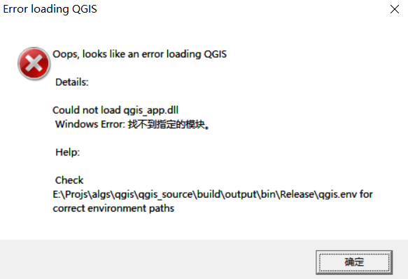
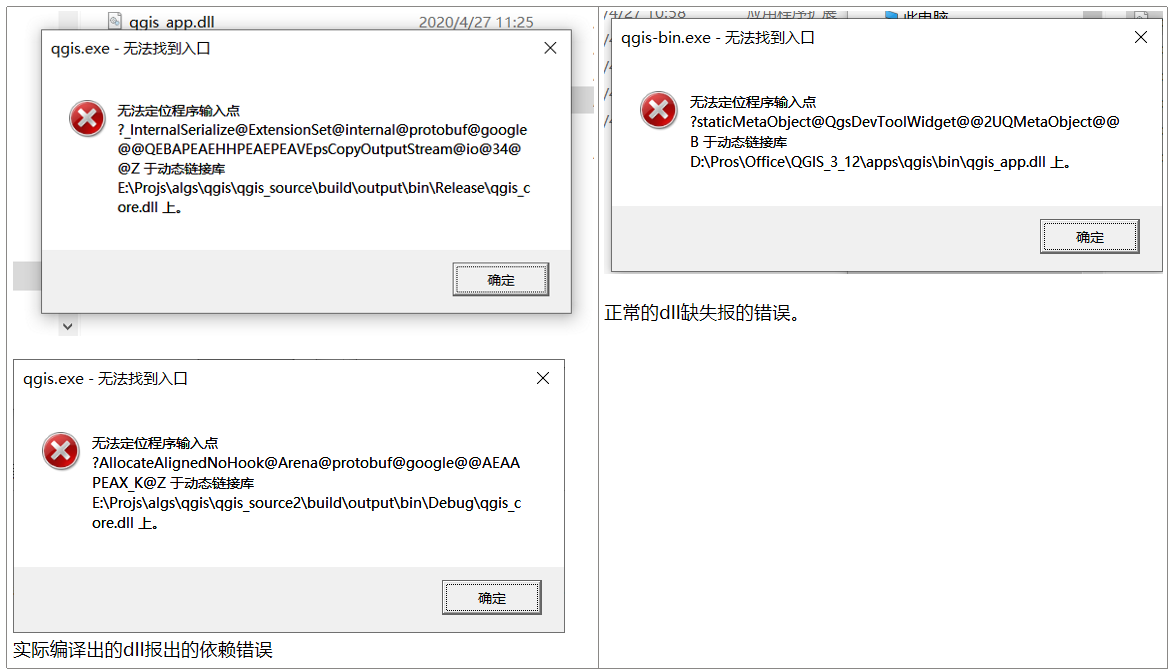
(3)Could not load qgis_app.dll.
Error loading QGIS
Oops, looks like an error loading Qgis, Details Could not load qgis_app.dll.
Window Erro: The specified procedure could not be found.
Help: Check c:OS.. qgis-bin.env for correct environmental paths.
解决方法(不可行):
出现这种问题可能是多删除了项目,保留下面几个项目。
(4)问题
E:Projsalgsqgisqgis_sourceuildoutputinRelease
猜测:
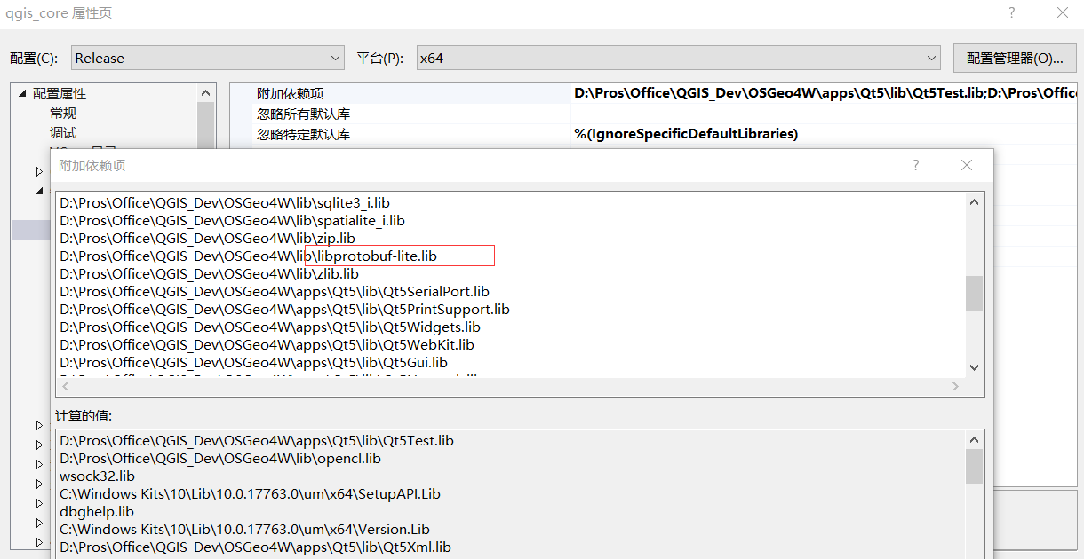
是否和 D:ProsIDEVS_LIBSvcpkgvcpkginstalledx64-windowsinclude__, 中的protobuf重复了。所以,将其include更改,再试一下。
发现不是和上述vcpkg中的protobuf冲突了,而是qgis_core.dll上引用的D:ProsOfficeQGIS_DevOSGeo4Wlib下的"libprotobuf-lite.lib", 将其改为 libprotobuf.lib 即可。
(5)version编译失败。
ModuleNotFoundError: No module named 'PyQt5.pyqtconfig'
1>------ 已启动生成: 项目: version, 配置: Release x64 ------ 1>Building Custom Rule E:/Projs/algs/qgis/qgis_source2/CMakeLists.txt 1>CMake is re-running because E:/Projs/algs/qgis/qgis_source2/build/CMakeFiles/generate.stamp is out-of-date. 1> the file 'E:/Projs/algs/qgis/qgis_source2/CMakeLists.txt' 1> is newer than 'E:/Projs/algs/qgis/qgis_source2/build/CMakeFiles/generate.stamp.depend' 1> result='-1' 1>-- Selecting Windows SDK version 10.0.17763.0 to target Windows 10.0.18363. 1>-- QGIS version: 3.13.0 Master (31300) 1>-- Found OpenCL C++ headers: D:/Pros/Office/QGIS_Dev/OSGeo4W/include 1>-- Could not find GRASS 7 1>-- Found Proj: D:/Pros/Office/QGIS_Dev/OSGeo4W/lib/proj_i.lib version 6 (6.3.1) 1>-- Found GEOS: D:/Pros/Office/QGIS_Dev/OSGeo4W/lib/geos_c.lib (3.8.1) 1>-- Found GDAL: D:/Pros/Office/QGIS_Dev/OSGeo4W/lib/gdal_i.lib (3.0.4) 1>-- Found Expat: D:/Pros/Office/QGIS_Dev/OSGeo4W/lib/expat.lib 1>-- Found Spatialindex: D:/Pros/Office/QGIS_Dev/OSGeo4W/lib/spatialindex-64.lib 1>-- Found Qwt: D:/Pros/Office/QGIS_Dev/OSGeo4W/apps/Qt5/lib/qwt.lib (6.1.3) 1>-- Found libzip: D:/Pros/Office/QGIS_Dev/OSGeo4W/lib/zip.lib 1>-- Found Sqlite3: D:/Pros/Office/QGIS_Dev/OSGeo4W/lib/sqlite3_i.lib 1>-- Found Protobuf: D:/Pros/Office/QGIS_Dev/OSGeo4W/lib/libprotobuf.lib 1>-- Found zlib: D:/Pros/Office/QGIS_Dev/OSGeo4W/lib/zlib.lib 1>-- Found PostgreSQL: D:/Pros/Office/QGIS_Dev/OSGeo4W/lib/libpq.lib 1>-- Found SpatiaLite: D:/Pros/Office/QGIS_Dev/OSGeo4W/lib/spatialite_i.lib 1>-- Qt WebKit support enabled 1>-- Found Qt version: 5.11.2 1>-- Found QScintilla2: D:/Pros/Office/QGIS_Dev/OSGeo4W/apps/Qt5/lib/qscintilla2_qt5.lib (2.10.8) 1>-- Found QtKeychain: D:/Pros/Office/QGIS_Dev/OSGeo4W/apps/Qt5/lib/qt5keychain.lib 1>-- Found QCA: D:/Pros/Office/QGIS_Dev/OSGeo4W/apps/Qt5/lib/qca-qt5.lib (2.1.3) 1>-- Pedantic compiler settings enabled 1>-- Found Python executable: D:/Pros/Office/QGIS_Dev/OSGeo4W/bin/python3.exe 1>-- Found Python version: 3.7.0 1>-- Found Python library: D:/Pros/Office/QGIS_Dev/OSGeo4W/apps/Python37/libs/python37.lib 1>-- Found Python site-packages: D:/Pros/IDE/Python37/Lib/site-packages 1>Traceback (most recent call last): 1> File "E:/Projs/algs/qgis/qgis_source2/cmake/FindPyQt5.py", line 34, in <module> 1> import PyQt5.pyqtconfig 1>ModuleNotFoundError: No module named 'PyQt5.pyqtconfig' 1> 1>During handling of the above exception, another exception occurred: 1> 1>Traceback (most recent call last): 1> File "E:/Projs/algs/qgis/qgis_source2/cmake/FindPyQt5.py", line 38, in <module> 1> import sipconfig # won't work for SIP v5 1>ModuleNotFoundError: No module named 'sipconfig' 1>Traceback (most recent call last): 1> File "E:/Projs/algs/qgis/qgis_source2/cmake/FindSIP.py", line 33, in <module> 1> import sipconfig 1>ModuleNotFoundError: No module named 'sipconfig' 1>CMake Error at cmake/FindSIP.cmake:54 (MESSAGE): 1> Could not find SIP 1>Call Stack (most recent call first): 1> CMakeLists.txt:891 (FIND_PACKAGE) 1> 1> 1>-- Configuring incomplete, errors occurred! 1>See also "E:/Projs/algs/qgis/qgis_source2/build/CMakeFiles/CMakeOutput.log". 1>See also "E:/Projs/algs/qgis/qgis_source2/build/CMakeFiles/CMakeError.log". 1>C:ProgramDevMicrosoft Visual Studio2017EnterpriseCommon7IDEVCVCTargetsMicrosoft.CppCommon.targets(209,5): error MSB6006: “cmd.exe”已退出,代码为 1。 1>已完成生成项目“version.vcxproj”的操作 - 失败。 |
移除完,不相干的内容。再去编译。
(6)Couldn't load SIP module.
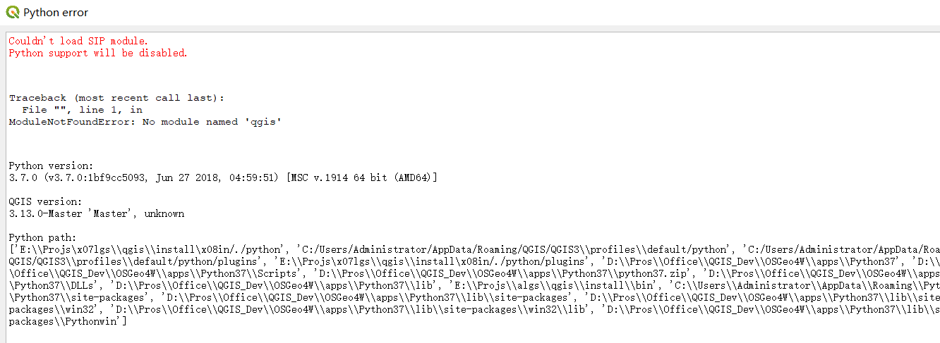
解决方法:
D:ProsOfficeQGIS_DevOSGeo4WappsPython37>python Scripts/pip.exe list
查看列出的结果(左侧)。
D:ProsOfficeQGIS_DevOSGeo4WappsPython37>python Scripts/pip.exe list Package Version ----------------- --------- bleach 3.1.0 certifi 2019.9.11 chardet 3.0.4 coverage 4.5.1 cycler 0.10.0 docutils 0.15.2 future 0.16.0 GDAL 3.0.4 idna 2.8 kiwisolver 1.1.0 matplotlib 3.1.3 mock 2.0.0 nose2 0.8.0 numpy 1.18.1 pbr 4.3.0 Pillow 5.3.0 pip 20.0.2 pkginfo 1.5.0.1 ply 3.11 psycopg2-binary 2.8.4 Pygments 2.4.2 PyOpenGL 3.1.0 pyparsing 2.4.6 PyQt5 5.11.3 python-dateutil 2.8.1 pywin32 224 PyYAML 5.3 readme-renderer 24.0 requests 2.22.0 requests-toolbelt 0.9.1 setuptools 41.2.0 sip 4.19.14 six 1.12.0 tqdm 4.36.1 twine 1.15.0 urllib3 1.25.5 webencodings 0.5.1 wheel 0.33.6 wxPython 4.0.7 WARNING: pip is configured with locations that require TLS/SSL, however the ssl module in Python is not available. Could not fetch URL https://pypi.org/simple/pip/: There was a problem confirming the ssl certificate: HTTPSConnectionPool(host='pypi.org', port=443): Max retries exceeded with url: /simple/pip/ (Caused by SSLError("Can't connect to HTTPS URL because the SSL module is not available.")) - skipping D:ProsOfficeQGIS_DevOSGeo4WappsPython37> | D:ProsOfficeQGIS_3_12appsPython37>python Scripts/pip.exe list Package Version ----------------- --------- bleach 3.1.0 certifi 2019.9.11 chardet 3.0.4 coverage 4.5.1 cycler 0.10.0 decorator 4.4.1 docutils 0.15.2 ExifRead 2.1.2 future 0.16.0 GDAL 3.0.4 geographiclib 1.50 httplib2 0.11.3 idna 2.8 ipython-genutils 0.2.0 Jinja2 2.11.1 jsonschema 2.6.0 jupyter-core 4.4.0 kiwisolver 1.1.0 lxml 4.3.3 MarkupSafe 1.1.1 matplotlib 3.1.3 mock 2.0.0 nbformat 4.4.0 networkx 2.2 nose2 0.8.0 numpy 1.18.1 OWSLib 0.17.0 pandas 1.0.1 pbr 4.3.0 Pillow 5.3.0 pip 20.0.2 pkginfo 1.5.0.1 plotly 3.3.0 ply 3.11 psycopg2-binary 2.8.4 Pygments 2.4.2 pyodbc 4.0.24 PyOpenGL 3.1.0 pyparsing 2.4.6 pypiwin32 223 pyproj 2.5.0 PyQt5 5.11.3 python-dateutil 2.8.1 pytz 2019.3 pywin32 224 PyYAML 5.3 readme-renderer 24.0 requests 2.22.0 requests-toolbelt 0.9.1 retrying 1.3.3 scipy 1.4.1 setuptools 41.2.0 Shapely 1.7.0 simplejson 3.16.0 sip 4.19.14 six 1.12.0 tqdm 4.36.1 traitlets 4.3.3 twine 1.15.0 urllib3 1.25.5 webencodings 0.5.1 wheel 0.33.6 wxPython 4.0.7 xlrd 1.1.0 xlwt 1.3.0 WARNING: pip is configured with locations that require TLS/SSL, however the ssl module in Python is not available. Could not fetch URL https://pypi.org/simple/pip/: There was a problem confirming the ssl certificate: HTTPSConnectionPool(host='pypi.org', port=443): Max retries exceeded with url: /simple/pip/ (Caused by SSLError("Can't connect to HTTPS URL because the SSL module is not available.")) - skipping D:ProsOfficeQGIS_3_12appsPython37> |
可以看到本该有的PyQt文件夹,没有在编译安装时,生成。
解决方法是,全部生成QGIS目录下原本有的项目。不要取消生成一部分项目,以提高所谓的生成速度。
而此时,千万不要听信网上的方法,删除 C:UsersAdministratorAppDataRoamingQGIS 下的QGIS3文件夹。
否则,你的个性化设置,将全部丢失。
(7)其它python所依赖的第三方库找不到的话,可以pip安装
D:ProsOfficeQGIS_DevOSGeo4WappsPython37>python Scripts/pip.exe install jinja2 -i http://pypi.douban.com/simple --trusted-host pypi.douban.com
(8)processing 菜单消失,processing box工具箱找不到
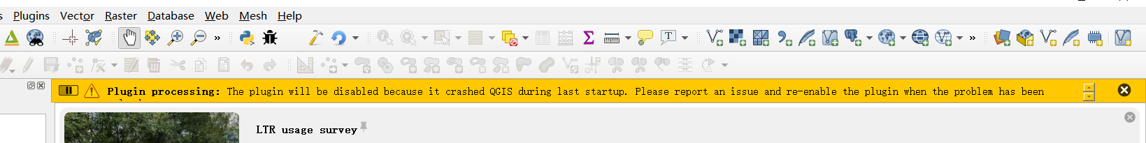
Plugin processing: The plugin will be disabled because it crashed QGIS during last startup. Please report an issue and re-enable the plugin when the problem has been solved.
可以在这个地方,看到QGIS的配置信息。
C:UsersAdministratorAppDataRoamingQGISQGIS3profilesdefaultQGISQGIS3.ini
解决方法:
在插件,已经安装的插件中,重新开启processing,这个核心的插件。
3.2 Packaging
To create a standalone installer there is a perl script named 'creatensis.pl' in 'qgis/ms-windows/osgeo4w'. It downloads all required packages from OSGeo4W and repackages them into an installer using NSIS.
The script can be run on both Windows and Linux.
On Debian/Ubuntu you can just install the 'nsis' package.
NSIS for Windows can be downloaded at:
And Perl for Windows (including other requirements like 'wget', 'unzip', 'tar' and 'bzip2') is available at:
3.3 Packaging your own build of QGIS
Assuming you have completed the above packaging step, if you want to include your own hand built QGIS executables, you need to copy them in from your windows installation into the ms-windows file tree created by the creatensis script.
cd ms-windows/
rm -rf osgeo4w/unpacked/apps/qgis/*
cp -r /tmp/qgis1.7.0/* osgeo4w/unpacked/apps/qgis/
Now create a package.
./quickpackage.sh
After this you should now have a nsis installer containing your own build of QGIS and all dependencies needed to run it on a windows machine.
3.4 Osgeo4w packaging
The actual packaging process is currently not documented, for now please take a look at:
ms-windows/osgeo4w/package.cmd